Soils in Rwanda
Senior 4 · Geography
Soils in Rwanda
Lesson 1 of 3
25 min
Soil scientists at Ghent University analysed Rwanda's national soil profile database and summed up the country's soils in one sentence: they range from Andosols in the volcanic highlands, through Cambisols, Luvisols, Alisols and Acrisols in the sub-humid, hilly western highlands, to strongly weathered Ferralsols in the semi-arid eastern lowlands (Van Ranst, Verdoodt and Baert, 2010). This lesson explains what those names mean, why each soil is where it is, and how one hill can carry several soils. (S2 introduced how soil forms; here we use the international soil names that Rwandan soil maps use.)
Figure 1: the horizons of a typical well-drained hill soil (a sketch).
Definition
Soil: the loose upper layer of the land surface, made of mineral particles, organic matter (humus), water and air, in which plants grow. Soil profile: a vertical section through the soil showing its layers, called horizons.
Leaching: the washing of dissolved nutrients down through the soil by rain water. Laterisation (ferralitisation): intense weathering and leaching in warm, wet climates that leaves soils rich in iron and aluminium oxides and poor in nutrients.
| Soil group | Main characteristics | Where in Rwanda |
|---|---|---|
| Andosols (volcanic soils) | Formed on volcanic ash and lava; dark, light, porous, rich in organic matter; hold water well; fertile but bind phosphate | Volcanic highlands of the north-west (Van Ranst and others, 2010); REMA notes the fertile volcanic soils near the Volcanoes National Park |
| Acrisols and Alisols | Strongly leached, acidic, low in nutrients; clay washed down into a red or yellow B horizon | Hilly western and central highlands, on schists and granites (Van Ranst and others, 2010) |
| Cambisols and Luvisols | Younger, moderately developed soils; Luvisols have a clay-enriched B horizon but are less leached and more fertile than Acrisols | Slopes of the hilly western highlands (Van Ranst and others, 2010) |
| Ferralsols | Very deep, strongly weathered, red or yellow; rich in iron and aluminium oxides, poor in plant nutrients; well drained | Semi-arid eastern lowlands (Van Ranst and others, 2010) |
| Histosols (peat soils) | Thick layers of partly decayed plant matter in waterlogged places; very high organic matter | High-altitude marshes; REMA lists peaty swamps such as Kamiranzovu in Nyungwe (REMA, 2009) |
| Vertisols | Dark, heavy clays that swell when wet and crack deeply when dry | REMA lists vertisols in the swamps of the Bugarama plain (REMA, 2009) |
| Alluvial soils (Fluvisols) | Layered sands, silts and clays laid down by rivers; usually fertile; often waterlogged | Valley floors and floodplains, largest along the Akagera (BGS alluvium, 2018) |
Warning
Acid soils are the rule, not the exception. REMA reports that, besides being acidic, most of Rwanda's soils are exhausted from continuous farming (REMA, 2009). An exam answer that calls all Rwandan soils "fertile" will lose marks; the fertile exceptions are the volcanic soils, young alluvium and well-managed valley soils.
The five soil-forming factors explain the pattern:
Figure 2: a soil catena. On one Rwandan hill the soil changes from crest to valley floor because of slope, drainage and the movement of material downhill.
Definition
Catena: a sequence of different soils down a slope, from the same parent rock and climate, which differ because of drainage, erosion and deposition along the slope.
Example: in Figure 2, the valley-floor soil is grey because waterlogging removes oxygen, so iron is reduced instead of forming red oxides.
Worked example 1: what controls organic carbon in Rwanda's topsoils?
Analysing 1,463 soil profiles, Van Ranst and colleagues (2010) found that altitude, the clay and fine silt content of the soil, and population density together explained 48% of the variation in topsoil organic carbon. Their equation is
where SOC is the topsoil organic carbon content (%), alt the altitude (m), cfs the clay and fine silt content (%) and pd the population density (people per km²).
(a) A highland site: alt = 2,200, cfs = 50, pd = 500.
(b) An eastern lowland site: alt = 1,400, cfs = 40, pd = 400.
Cooler highland soils keep more than twice the organic carbon of warm lowland soils, and every extra person per km² lowers it: decomposition is faster where it is warm, and dense farming removes plant material. (The authors note that the equation does not apply to the volcanic soils of the Volcanoes National Park.)
Tip
Reading a soil in the field: colour (dark = humus; red = well-drained iron oxides; grey or mottled = waterlogged), texture (rub moist soil: gritty = sand, silky = silt, sticky = clay), depth to rock, and stones. Record them for each horizon with a sketch of the profile.
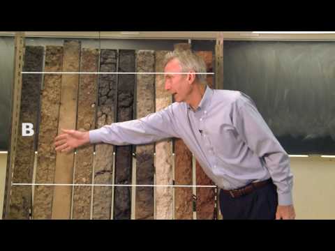
Purdue Extension: "Soil Basics: Soil Profiles". A soil scientist explains the horizons of a real profile. As you watch, match each horizon to Figure 1.
Practice
Key points
Sources and credits
Sources: Soil Mapping in Africa at the Crossroads: Work to Make up for Lost Ground, E. Van Ranst, A. Verdoodt and G. Baert, Bulletin des Séances de l'Académie Royale des Sciences d'Outre-Mer, 56(2), 2010, pp. 147–163 (soil groups of Rwanda, organic carbon equation); Rwanda State of Environment and Outlook Report, REMA, 2009 (acid soils, peat and vertisol swamps, volcanic soils); Africa Groundwater Atlas: Hydrogeology of Rwanda, British Geological Survey, 2018 (alluvium). Facts only; the text was written by Ganzaa.
Figures 1 and 2, the worked example and the exercises were drawn and written by Ganzaa.
Video: "Soil Basics: Soil Profiles", Purdue Extension, embedded from YouTube.
Quick check
Match each soil group to where it is found in Rwanda.
Tap one on the left, then its partner on the right.