The Origin and Distribution of the Continents
Senior 6 · Geography
The Origin and Distribution of the Continents
Lesson 2 of 4
25 min
Wegener died in 1930 without explaining what moves the continents. The answer lay on the ocean floor, which almost nobody had studied. After the Second World War, ships with echo sounders and magnetometers mapped it for the first time. In the 1950s Marie Tharp and Bruce Heezen drew a mountain range running down the middle of the Atlantic, split along its crest by a deep valley. Rocks on the ocean floor also carried a strange pattern of magnetism. These discoveries turned continental drift into the theory of plate tectonics.
Definition
Lithosphere: the rigid outer shell of the Earth, made of the crust and the uppermost mantle, typically about 100 km thick. Asthenosphere: the hot, weak layer of the upper mantle beneath it, which can flow very slowly.
Tectonic plate: one of the large, rigid pieces into which the lithosphere is broken. Plates move over the asthenosphere and carry continents, ocean floor, or both. Example: the African plate carries the whole of Africa and part of the Atlantic and Indian Ocean floors.
Definition
Mid-ocean ridge: an underwater mountain range where two plates move apart, with a rift valley along its crest. Seafloor spreading: the process by which magma rises at a mid-ocean ridge, cools to form new ocean floor, and is carried away on both sides as the plates separate (proposed by Harry Hess in 1962).
Magnetic reversal: a switch of the Earth's magnetic field, so that a compass would point south. Lava records the field that exists as it cools, so rocks of different ages show normal or reversed polarity.
Figure 3: magnetic stripes either side of a mid-ocean ridge. The widths follow the known dates of the last five changes of polarity, for a ridge spreading at 25.6 km per million years on each side.

Worked example 1: a spreading rate from the stripes
Problem. The most recent reversal took place about 0.78 million years ago. In Figure 3 the boundary of the central stripe lies 20 km from the ridge axis. Find the spreading rate on each side, in cm per year, and the total rate at which the two plates separate.
Solution.
Both plates move away from the ridge, so they separate at .
Worked example 2: the age of the ocean floor
Problem. A ridge spreads at 1.5 cm per year on each side. How old is the ocean floor 1,500 km from the ridge? Why can ocean floor never be as old as the oldest continents?
Solution.
Ocean floor is dense and, when it grows old, cold and heavy, it sinks back into the mantle at deep-sea trenches (subduction), so it is constantly recycled. Continental crust is too light to sink, so very old continental rock survives.
By the late 1960s the pieces fitted into one theory: the lithosphere is broken into plates; new plate forms at mid-ocean ridges and old plate is destroyed at trenches, so the Earth does not grow; most earthquakes, volcanoes and mountain belts occur where plates meet.
| Feature | Oceanic crust | Continental crust |
|---|---|---|
| Main rock | Basalt (dark, rich in iron and magnesium) | Granite and related rocks (light, rich in silica and aluminium) |
| Thickness | About 5–10 km | About 30–70 km (thickest under mountains) |
| Density | About 3.0 g cm⁻³ | About 2.7 g cm⁻³ |
| Age | Almost all less than 200 million years | Up to about 4 billion years |
| Fate at a trench | Can sink (be subducted) | Too buoyant to sink |

Seven plates are usually counted as major: the Pacific (the largest), North American, Eurasian, African, Antarctic, Indo-Australian (often divided into the Indian and Australian plates) and South American. Smaller plates include the Nazca, Cocos, Caribbean, Arabian, Philippine Sea, Juan de Fuca and Scotia plates. Some plates are almost all ocean floor (the Pacific, the Nazca); most carry both ocean floor and a continent (the African, the South American).
Plates move at a few centimetres a year. The U.S. Geological Survey gives about 2.5 cm per year for the Mid-Atlantic Ridge and more than 15 cm per year for parts of the East Pacific Rise, the fastest spreading ridge.
Warning
Plates are not continents, and the asthenosphere is not a sea of lava. A plate boundary may run through the middle of an ocean (the Mid-Atlantic Ridge) or across a continent (the East African Rift). The asthenosphere is almost entirely solid rock that flows extremely slowly, like very stiff putty; only small amounts melt, for example under ridges.
Tip
Units trap. Spreading-rate questions mix kilometres, centimetres, years and millions of years. Convert everything to centimetres and years before dividing, and say whether your answer is the rate on one side (half rate) or the total rate of separation.
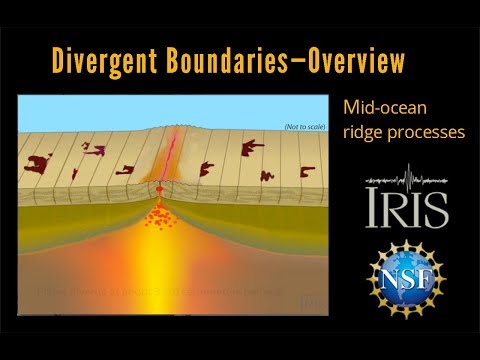
IRIS Earthquake Science: "Divergent Boundary—Fast Spreading Ridge Educational". An animation of new ocean floor forming at a mid-ocean ridge as the plates move apart. Watch where the magma rises and how new lithosphere forms at the ridge as the plates move apart.
Practice
Summary
Sources and credits
Figure 3 was drawn by Ganzaa from the dates of the last five magnetic reversals. The worked examples and exercises were written by Ganzaa.
Video: "Divergent Boundary—Fast Spreading Ridge Educational", IRIS Earthquake Science, embedded from YouTube.
This lesson adapts CC BY-SA material and is shared under CC BY-SA 4.0.