Drainage in Africa and the World
Senior 3 · Geography
Drainage in Africa and the World
Lesson 1 of 4
25 min
Let's begin
Rain that falls on the hills above Rubavu can end up in the Atlantic Ocean. Rain that falls a few kilometres to the east, on the other side of the same ridge, can end up in the Mediterranean Sea, after a journey through Lake Victoria, Uganda, South Sudan, Sudan and Egypt. Rwanda sits on one of the great water partings of Africa. This lesson explains how rivers organise themselves into basins, and maps the great rivers of Africa and the world.
Definition
Drainage: the way water flows off the land in rivers, streams and lakes. Drainage basin (or catchment): the whole area of land drained by a river and its tributaries. Watershed (or divide): the high ground that separates one drainage basin from the next. Example: the Congo–Nile divide in western Rwanda.
| Term | Meaning | Rwandan or African example |
|---|---|---|
| Source | Where a river begins: a spring, a lake or a marsh in the hills | The Sebeya rises at about 2,660 m in the mountains of the Congo–Nile divide (RWB, 2019) |
| Tributary | A smaller river that joins a larger one | The Mwogo, Rukarara and Mbirurume feed the Upper Nyabarongo (RWB, 2019) |
| Confluence | The point where two rivers meet | The Nyabarongo begins at the confluence of the Mwogo and Mbirurume (RWB, 2019); the White and Blue Niles meet at Khartoum |
| Mouth | Where a river enters a sea, lake or larger river | The Sebeya enters Lake Kivu at Rubavu, at about 1,470 m (RWB, 2019) |
| Delta | A fan of sediment at a mouth, cut by many channels | The Nile delta in Egypt; the Niger delta in Nigeria |
| Estuary | A wide, tidal mouth where river and sea water mix | The mouth of the Congo |
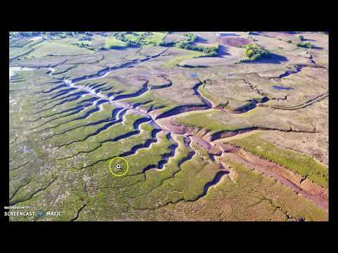
Seen on a map, rivers and their tributaries form patterns. The pattern depends on the rock, the slope and the structure of the land (Figure 2).
Figure 2: six drainage patterns. Drawn by Ganzaa.
B Hosein, a geography teacher: Drainage Patterns. Watch for how each pattern is linked to the rock type and the structure of the land.
Figure 1: the main rivers and lakes of Africa.
| River | Length (Wikipedia) | Rises in | Flows into | Notes |
|---|---|---|---|---|
| Nile | over 6,600 km | The highlands around Lake Victoria (White Nile) and Lake Tana in Ethiopia (Blue Nile) | Mediterranean Sea, through a delta | Longest river in Africa; crosses the Sahara with little added water |
| Congo | about 4,700 km, measured with the Lualaba–Chambeshi headwaters | Highlands of Zambia and the DR Congo | Atlantic Ocean, through an estuary | Basin of about 4,000,000 km²; the world's deepest recorded river |
| Niger | about 4,180 km | Guinea Highlands, close to the Atlantic | Gulf of Guinea, through a delta | Flows north-east into the Sahel, then turns south-east |
| Zambezi | about 2,574 km | North-western Zambia | Indian Ocean | Victoria Falls; Kariba and Cahora Bassa dams |
The Nile basin covers parts of eleven countries. The White Nile carries a steady flow from the rainy lake plateau; the Blue Nile and Atbara bring a summer flood from the Ethiopian Highlands, which once flooded Egypt every year. The Congo basin straddles the Equator, so one part or another always has its rainy season, and the Congo's flow is large and steady all year.
The Amazon (South America) carries more water than any other river. The Mississippi–Missouri drains the interior plains of North America to the Gulf of Mexico. The Yangtze and Huang He water the plains of China; the Ganges and Indus flow from the Himalayas; the Danube and Rhine are the great navigable rivers of Europe; the Murray–Darling drains south-eastern Australia.
The Rwanda Water Resources Board describes Rwanda's rivers as draining to two great basins (RWB catchment plans, 2019). West of the Congo–Nile divide, the Sebeya catchment is "one of the most upstream parts of the Congo River basin": its water flows into Lake Kivu, then by the Rusizi to Lake Tanganyika and on to the Congo and the Atlantic. East of the divide, the Upper Nyabarongo catchment lies "within the Nile basin": the Nyabarongo flows to the Akagera River and Lake Victoria, the main reservoir of the White Nile. RWB calls the Upper Nyabarongo catchment Rwanda's "water tower".
Figure 3: the Congo–Nile divide, simplified. Heights from RWB (2019); drawn by Ganzaa.
Worked example
Worked example 1: catchment areas. RWB (2019) gives Rwanda's total area as 26,338 km². The Upper Nyabarongo catchment covers 3,348 km² and the Sebeya catchment 336.4 km². What percentage of Rwanda does each cover?
Worked example
Worked example 2: gradient of a river. The Sebeya falls from about 2,660 m at its source to 1,470 m at Lake Kivu over 48 km (RWB, 2019). Calculate its average gradient.
Warning
"Watershed" has two meanings. In British and East African geography it means the divide between basins, as used here; in American usage it often means the basin itself. In your exam, define the term before you use it.
Tip
Read the pattern, then name the rock. Tree-like: uniform rock. Right angles between ridges: folded rock (trellis). Right angles everywhere: joints and faults (rectangular). Spokes out: a volcano or dome. Spokes in: a basin or lake.
Practice
Sources and credits
This lesson adapts CC BY-SA material and is shared under CC BY-SA 4.0.