Global Drainage Systems
Senior 6 · Geography
Global Drainage Systems
Lesson 3 of 5
25 min
Rivers do not keep their courses for ever. In East Africa, the uplift of the land along the western arm of the Rift Valley tilted the ground back towards the east. Rivers that once flowed west towards the Congo basin, such as the Kagera, the Katonga and the Kafu, were reversed and now flow east. Water ponded behind the uplifted block and helped to form Lake Victoria, and the drowned valleys of the Kafu system became the shallow, finger-like Lake Kyoga in Uganda. Earth movements, changes in sea level and the work of neighbouring rivers all rearrange drainage; this lesson looks at how.
Definition
River capture (river piracy): the diversion of the upper course of one river into the system of another, more vigorous river.
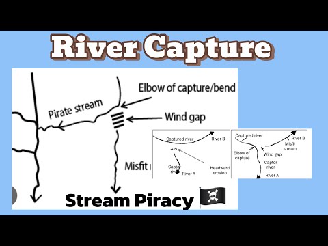
Captor: the river that captures. Captured stream: the headwaters diverted. Elbow of capture: the sharp bend where the diversion happens. Wind gap: the dry valley left between the elbow and the beheaded river. Misfit stream: the shrunken river left below the wind gap, too small for its valley.
Rejuvenation: the renewal of a river's power of vertical erosion, caused by a fall in base level or an increase in discharge.
Drainage pattern: the arrangement of a river and its tributaries in plan.
Capture happens when one river has more erosive power than its neighbour: a steeper gradient (because it flows to a lower base level), softer rocks in its path, or more rainfall in its basin. A tributary of the stronger river cuts back its head (headward erosion) until it breaks through the watershed and diverts the weaker river.
Figure 1: river capture in three stages. A is the captor, T its tributary and B the river that is captured.
The evidence for capture is a set of features found together: an elbow of capture, a wind gap, a misfit stream in a valley too wide for it, and a knickpoint on the captor just below the elbow, because the extra water gives the captor more power to cut down. A documented example is in north-east France, where the upper Moselle once flowed west past Toul to join the Meuse; it was captured by the Meurthe, and the dry valley between Toul and the Meuse, the Val de l'Âne, is the wind gap.
| Cause | Type | How it works |
|---|---|---|
| Fall in sea level (for example in a glacial period, when about 120 m of sea water was locked in ice sheets) | Dynamic: eustatic | The river must cut down to the new, lower base level |
| Uplift of the land by earth movements or by the land rising after ice sheets melt | Dynamic: tectonic or isostatic | The river is now higher above base level and cuts down |
| More discharge, from river capture or a wetter climate | Static | More water gives more energy for vertical erosion with no change in base level |
Rejuvenation starts at the mouth and works upstream: a new, steeper section meets the old graded profile at a knickpoint, often a waterfall or rapids, which retreats upstream. Its landforms are:
Figure 2: paired river terraces in a rejuvenated valley.

Worked example 1: how far has a knickpoint travelled?
Problem. A knickpoint formed when sea level fell at the end of an interglacial. Today it lies 3.6 km upstream from the river mouth. If it has retreated at an average 0.30 m per year, about how long ago did it form? (Illustrative rate.)
Solution.
Real retreat rates vary greatly with rock hardness and discharge, so such estimates are rough; geographers check them by dating the terraces.
Worked example 2: reading the evidence of capture on a map
Problem. A map shows a river flowing south that turns sharply east through a right angle; directly south of the bend a dry, flat-floored valley crosses a ridge, and beyond it a small stream flows south in a valley 1 km wide. Interpret the evidence.
Solution. The right-angled bend is an elbow of capture; the dry valley is a wind gap through the former watershed; the small stream in the wide valley is a misfit, the beheaded remnant of the original river. The river now flowing east is the captor, which must have had the steeper gradient. A geographer would look next for a knickpoint on the captor just below the elbow to confirm it.
Figure 3: six drainage patterns and the conditions that produce them.
| Pattern | Conditions | Examples |
|---|---|---|
| Dendritic | Rock of uniform resistance, gentle slopes; tributaries join at acute angles | The most common pattern; much of the Congo and Amazon basins |
| Trellis | Alternate parallel bands of hard and soft rock; subsequent streams follow the soft bands and join the consequent at right angles | The folded Appalachian Mountains, USA |
| Radial | Streams flow out in all directions from a central high point | Mount Elgon, Mount Kenya and Kilimanjaro |
| Centripetal | Streams converge on a central basin | The Lake Chad basin |
| Rectangular | Streams follow joints and faults that cross at right angles | Jointed granite and fault-broken plateaus |
| Parallel | Streams run side by side down a steep, uniform slope | Steep rift-valley escarpments |
Most rivers follow the structure of the rocks beneath them (accordant drainage). Some cut straight across it (discordant drainage), for one of two reasons:
A river crosses a mountain ridge in a deep gorge. What evidence would help you decide whether it is antecedent or superimposed?
Warning
Common mistakes
Tip
Memory hook. For capture, think of a theft: the captor is the thief, the elbow is where it grabbed, the wind gap is the empty room and the misfit is the victim left with too little.
GeoWith Motsoko: "River Capture/Stream Piracy", a Grade 12 lesson from South Africa. Identify the captor, the captured stream, the elbow of capture, the wind gap and the misfit stream, and compare them with Figure 1.
Practice
Summary
Sources and credits
Photo: Goosenecks San Juan River Utah 2020 (Jstuby, CC0), via Wikimedia Commons.
Video: "River Capture/Stream Piracy", GeoWith Motsoko, embedded from YouTube.
Figures 1 to 3, the worked examples and the exercises were drawn and written by Ganzaa.
This lesson adapts CC BY-SA material and is shared under CC BY-SA 4.0.